A major earthquake measuring 7.7 on the Richter Scale, has triggered a tsunami which struck southern Java, Indonesia, at approximately 3.20 pm local time (6.20 pm EST) on Monday 17 July 2006.
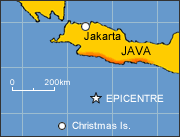
Occurring 360km south of Jakarta at a depth of 10km, the earthquake created a tsunami estimated to be between 2 metres and 6 metres high, which struck Cilacap, Kebumen and Pangandaran in southern Java.
Map of tsunami affected region
Australia has allocated $250,000 for emergency relief and short to medium term assistance, including:
- $100,000 to the Indonesian Red Cross (PMI) for emergency and relief supplies
- $150,000 through international aid agencies and non-government organisations to restore water and sanitation services and re-establish livelihoods - with a focus on fishing communities.
Official reports indicate that 656 people are dead and approximately 20,000 remain displaced. Dozens remain missing.
Two AusAID personnel have undertaken on-the-ground assessments in the worst affected areas, and participated in donor coordination meetings.
How you can help
For more information on how you can help see the Australian Council for International Development website [external].
27 July 2006
![]()